
A local history
History of Menangle Park
Dharawal Country, the river, farming, the railway and the racecourse. Follow the stories that shaped Menangle Park, from its earliest records to a changing community.
Menangle Park is on Dharawal country. Its history connects the Nepean River, farming estates, the railway and the racecourse with the residential community developing around the older village. Follow the dated events below, or use the era links to move through the story.
Two places, one river. Menangle Park (2563) is in Campbelltown City; Menangle (2568) is in Wollondilly Shire. The Nepean separates them. The railway viaduct crosses that boundary, so its story belongs to both banks.
Dharawal Country and the river
Campbelltown City Council names the Dharawal people as the Traditional Custodians of the area, uses the spelling “Dharawal” throughout its current website, and closes its pages with an Acknowledgement of Country on Dharawal country. Council describes Dharawal country as the land between two rivers, the Nepean and the Georges, and as a meeting place for mobs to unite, yarn, trade, discuss lore and resolve grievances. Menangle Park sits on the Nepean, one of those two rivers.
Heritage NSW describes Glenlee as a rural cultural landscape including elements of Aboriginal heritage significance, and says the area close to the house has high archaeological potential associated with Dharawal occupation before and immediately after European settlement.
Reading the place name
Campbelltown Council’s own history page for the suburb, which reproduces a 1995 local history with its authors’ permission, says the name derives from an Aboriginal word spelt either Manhangle or Manangle, used by the Tharawal people for a small lagoon on the opposite side of the Nepean. A non-Indigenous heritage study of Menangle Park, commissioned by Landcom and Council and attached to a 2018 Council meeting item, gives a different gloss: the name “is thought to” be “Menhangle”, meaning “the place of many swamps”, and it notes that before the Upper Nepean Scheme of the 1880s a series of lagoons east of the river made the district much wetter.
The eastern farming community was known as North Menangle before the racecourse gave the district its present name. Council records the connection with the course that opened in 1914.
1805–1859 · Farms and early settlement
1805 A farm named Manangle across the river
Council’s history records a 2,000-acre grant to Walter Davidson on the west bank of the Nepean in 1805. He called his farm Manangle after a lagoon there. The estate was later absorbed into John Macarthur’s Camden Park, and the private village of Menangle grew on it. That village is in Wollondilly Shire today; this event is included to explain the shared name across the river.
References
17 April 1816 The Appin massacre
Council states that in 1816 Governor Macquarie ordered an attack on Dharawal people living in the Cow Pastures, describes it as “the first military ordered massacre of Aboriginal people in Australia”, dates it to 17 April 1816, and acknowledges its ongoing impact - many who survived fled to neighbouring country and some have not returned. Heritage NSW’s notes for Glenlee record the same sequence from the colonial side: accelerating land grants, tension culminating in the Appin massacre of 1816, and a population reduced afterwards by disease and loss of hunting grounds. This regional event is included because of its significance to Dharawal Country.
References
January 1818 Glenlee takes shape
Governor Macquarie granted the free settler William Howe 3,000 acres east of the river in January 1818. Howe named the estate Glenlee after his birthplace in Scotland and built the house to a design by Henry Kitchen, occupying it by 1824. Heritage NSW calls it one of only a handful of early surviving colonial houses in the Sydney region, a rare example of Old Colonial Regency style.
References
1820s–1900 Farming the Nepean flats
Glenlee is why these Nepean flats became dairy country. Heritage NSW records that Howe took up dairying in the 1820s, half a century before it was general in the district, and that Glenlee’s “Sun and Thistle” butter was the first exported to England from New South Wales. By 1900 landholders here had almost all concentrated on dairying, and in 1949 Glenlee still ran three working dairies and part of a fourth.
References
Menangle House and the Horse and Jockey
Menangle House on Menangle Road was built by George Taber, a gentleman farmer, and Campbelltown Council records that it was for a time operated as the Horse and Jockey Inn. The licensed premises historically known as the Horse and Jockey sit just outside the paceway grounds and trade today as Menangle Country Club. Secondary write-ups date Menangle House variously to 1820 and 1834.
Source: Council history.
1859 The Fitzpatrick family at Glenlee
The estate passed from Howe to James Fitzpatrick, an emancipated convict who had arrived in 1822. The Fitzpatricks held Glenlee from 1859 until 1968-69, when the State Planning Authority and Macarthur Development Board acquired it.
References
1862–1900 · Railway and river crossings
1862–1863 A railway crossing over the Nepean
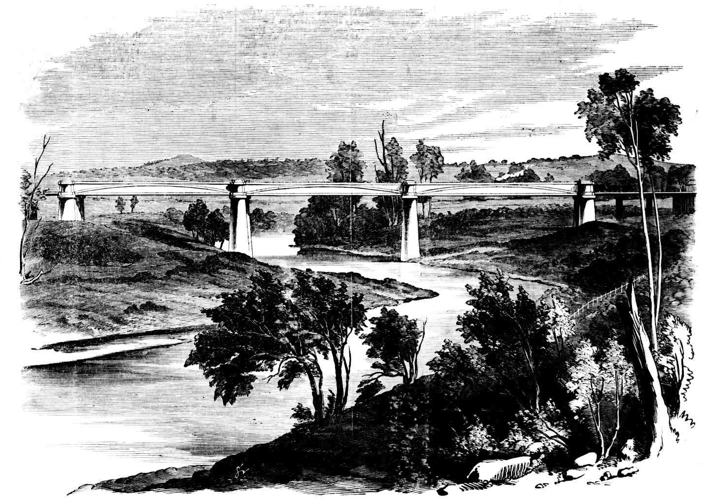
The line reached Campbelltown in 1858, and a platform opened on the northern bank of the Nepean in August 1862 while the crossing was built. The viaduct, completed in 1863, was the first large iron bridge in New South Wales and the largest in the colony until the Hawkesbury River Bridge of 1889. Heritage NSW calls it the oldest surviving bridge on the State rail system and rates it of national, if not international, significance.
The engraving was published in 1864, after the bridge’s completion in 1863. Campbelltown’s heritage schedule lists the viaduct under Menangle Park; Heritage NSW gives a Menangle address. The crossing spans the river boundary.
References
1873 / 1885 Different records of the early platform
Station dates are less settled. Council’s history says a North Menangle platform opened in April 1873 south of the modern station; Heritage NSW says one opened in August 1885 and was renamed North Menangle in 1889. Both agree the present station opened on its current site in 1937.
References
1914–1960 · Racing, wartime and village life
6 August 1914 Menangle Park Racecourse opens
Menangle Park Racecourse opened in 1914 as a thoroughbred course, not a harness track. Heritage NSW records that horse racing had been held beside the railway since the 1870s, and that J.J. Smith, H. Pateson and Dr L.J. Lamrock acquired 80 acres and laid a new track. The first meeting was on 6 August 1914, and three grandstands were designed by local architect Alfred Rose Payten. The military took the course over in both wars, latterly as an RAAF aerodrome with a runway through the middle of the track.
The farming community on the eastern, Campbelltown side was known as North Menangle. Council records that when Menangle Park Racecourse opened in 1914 the name became so bound up with the district that North Menangle renamed itself after it.
1916 Camels at Menangle Park
The Australian War Memorial holds four photographs whose records give the place as Menangle Park, NSW, and the year as 1916. They show members of the AIF training as reinforcements for the Imperial Camel Corps: men standing with a saddled camel, one man working a camel alone, and a group being given a demonstration of saddling. One record adds that the camel in the frame was donated to the corps by Mr Abdul Wahid, recorded as Wade, who branded his animals A33. Three of the four were given to the Memorial by a donor recorded only as G. Henderson.
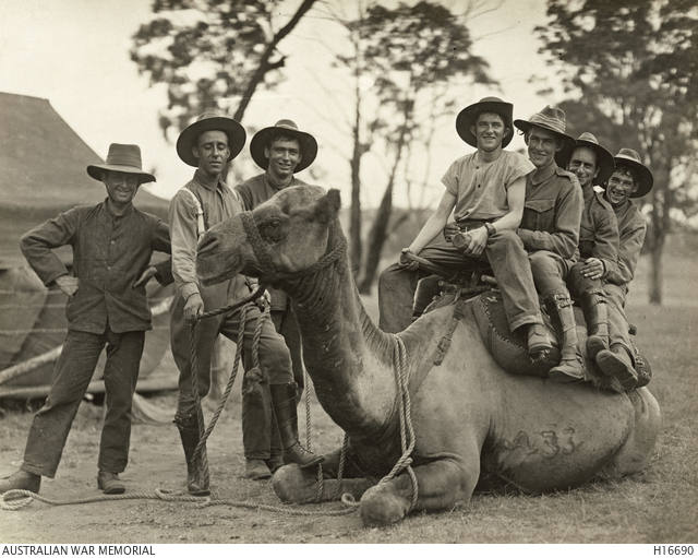
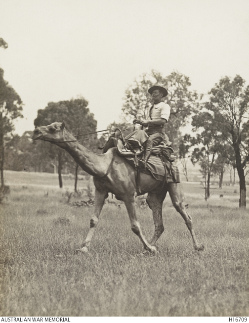
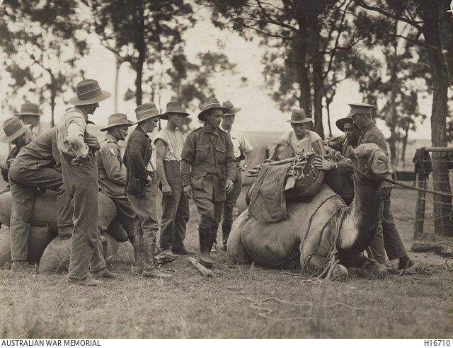
Training for the Imperial Camel Corps
The Memorial’s published paper on Australians in the Imperial Camel Corps describes reinforcements recruited from Light Horsemen training in Australia during 1916. It says the soldiers were based at Menangle Park and travelled to Sydney Zoo in batches for camel training. It also records Abdul Wade’s loan of six camels to the army for training at Menangle Park in June 1916.
The Memorial’s account describes training at Sydney Zoo and dates the loan of six camels to June 1916. The photographs show training at Menangle Park in 1916, but their catalogue records do not give a month or identify them as that same group of six camels.
Read the photograph records and the differing accounts
The wording of the records is itself worth noticing. The Memorial catalogues these photographs under “Menangle Park, NSW” and dates them to 1916, two years after the racecourse gave the district that name in place of North Menangle. The records do not establish when those descriptions were written. The 1864 engraving further up this page cannot be labelled that way, because in 1864 there was no Menangle Park to label: the name belonged to the west bank, and this side was the north of it.
That is the whole of what the four records say. They give no unit, no number of men, no duration and no place within the suburb. The racecourse section above records that the military took the course over in both wars, on Heritage NSW’s account — but nothing in the records places these photographs at the course, so the two should not be read as one story until something joins them.
Three things about this are unsettled, and are left that way rather than tidied:
- Lent or given. The Memorial’s paper says Wade lent the camels. The caption on H16690 says the camel in it was donated to the corps. The ABC, reporting Ryan Butta’s research in August 2022, says Wade donated camels to the war effort. Two of the three say given; the institution holding the photographs says both things in different documents.
- Where Wade was from. The paper’s footnote calls him a camel merchant in Western Australia. The ABC places him at Bourke, in north-western New South Wales, and describes him as an Afghan cameleer whose reputation there divided the town. The footnote cites Reid’s The Fighting Cameliers for the background, not for the six camels.
- Which Menangle. The Memorial catalogues the same activity under two place names: four photographs as “Menangle Park, NSW” and at least one, C378662, as “Menangle Camp, New South Wales”. The records do not settle which side of the river the camp stood on — the Memorial’s current catalogue uses both names, but those descriptions do not establish when the naming difference arose.
A 1939 photograph of a house on Moreton Park Road is a picture of Menangle, across the river in Wollondilly Shire, not of Menangle Park. The 1864 engraving further up this page shows the viaduct, which crosses the Nepean — the boundary between the two — and Campbelltown LEP 2015 lists it under Menangle Park in the heritage list below.
1920–1921 A village beside the course
The village came from a 1920-21 subdivision of 2.5-acre blocks beside the course, and its street names still carry the founding families: Fitzpatrick, Cummins and Taber, alongside Payten and Racecourse Avenue.
References
1937 The station moves to its present site
Council’s history and Heritage NSW’s account both record that the present station opened on its current site in 1937. The earlier platform dates differ, as set out in the railway chapter.
References
1952–1953 The move to harness racing
Harness racing arrived in 1952-53. Council confirms the NSW Trotting Club acquired the site in 1952 and redeveloped it as a paceway; a fuller timeline carried on Wikipedia, only partly corroborated, has the remodelled track opening on 26 September 1953 and night trotting from 2 November 1964.
References
1955 Residents seek subdivision
Residents had been lobbying to subdivide their 2.5-acre blocks since at least 1955, according to Council’s history of the suburb. The later planning story describes why urban development took decades to follow.
References
January 1960 Swimming lessons in the river
Council also records that the river reserve was a popular swimming hole from the 1920s, with 160 pupils enrolled for lessons in the river in January 1960. That is history, not a current permission - see weekends here.
References
1968–2026 · Planning a changing community
1968 / 1973 A future urban suburb
Council’s history page, which reproduces a 1995 local history, says Menangle Park was designated a future urban suburb in 1973. A 2010 air quality review prepared on behalf of Landcom and Council says the release area had been earmarked for urban development since 1968.
Council’s history gives the reason development did not follow for decades: a government ban on new suburban releases in the Nepean River catchment. The 2010 review says development was first expected in the late 1980s and early 1990s, and planning stalled in 1990 over air and water quality concerns in South Western Sydney.
References
1982 Glenlee receives a conservation order
A Permanent Conservation Order went over Glenlee House and part of the estate in 1982. Heritage NSW notes it has since been sold back into private ownership on about 45 acres. It is not a museum and is not open to the public.
References
17 December 2002 Council resumes release-area planning
The Department of Planning and Infrastructure’s January 2012 planning team report records that Council resolved on 17 December 2002 to prepare a draft local environmental plan and local environmental study for the land. The 2010 review records a State government announcement at the end of 2001 to investigate further Western Sydney release areas, including Menangle Park.
References
Department planning team report, January 2012 and 2010 air quality review.
2004–2006 Coal beneath the site delays planning
The January 2012 planning team report says planning was put on hold in 2004 pending a State decision on the coal beneath the site. In a letter of 4 May 2006, the Department advised that mining there should be restricted so urban development could proceed at a viable scale.
References
24 June 2008 A new paceway circuit
The new 1400-metre track opened on 24 June 2008, on the secondary reporting cited in the original racing account. Rebuild works began in 2000; the NSW Harness Racing Club members’ vote to sell Harold Park followed on 26 October 2008, and Harold Park’s last meeting was on 17 December 2010. The reporting sequence is recorded in the Menangle Park and Harold Park paceway articles, citing Sydney Morning Herald and Sun Herald reports from December 2010.
Club Menangle, as the club is now branded, describes the 1400-metre circuit as the fastest harness racing track in Australia and runs a museum in the underground walkway at Trackside - see weekends here.
References
2010–2013 Studies, proposal and public exhibition
The January 2012 planning team report records a draft study prepared in 2010 drawing on 18 technical studies, and the Department’s receipt of the planning proposal on 23 December 2011. Council’s October 2016 planning proposal records the draft rezoning exhibition from 11 December 2012 to 1 February 2013.
References
2015–2016 A regional growth proposal and a development tender
The Department’s 2016 consultation update records the release of the Greater Macarthur Preliminary Strategy on 22 September 2015, covering Wilton New Town and Menangle Park–Mount Gilead, and exhibition until 18 November 2015.
Landcom, then UrbanGrowth NSW, announced on 10 November 2015 that Dahua Group had won the tender for the Menangle Park residential subdivision. Its announcement described that proposal at the time as about 2,300 lots. The proposal to include Menangle Park and Mount Gilead in a Greater Macarthur Priority Growth Area was open for comment from 29 July to 7 September 2016.
References
Landcom tender announcement, Department consultation update and 2016 exhibition.
17 November 2017 The release area is rezoned
Amendment No 3 to Campbelltown LEP 2015 was published and came into force on 17 November 2017. The Planning Portal’s decision record describes rezoning for urban development and approximately 3,400 lots across the release area. The publication and commencement date comes from the LEP instrument as made. That figure describes the whole release area at that stage, rather than the later dwelling or lot yield on Dahua’s land.
References
2017 LEP instrument as made and Planning Portal decision record.
2018–2019 Greater Macarthur planning
The Department records exhibition of the draft Greater Macarthur 2040 plan from November 2018 to February 2019, and declaration of Greater Macarthur as a growth area in 2019.
References
29 April 2022 A further change to zones and yield
A further LEP amendment published on 29 April 2022 rearranged the zones and moved the local centre. Council’s March 2022 planning proposal describes the yield on Dahua’s land as rising from 3,000 to 4,000 dwellings. The Department’s April 2022 finalisation report also describes about 4,000 dwellings, an increase of about 1,000. Council’s October 2024 Local Planning Panel report describes the 2022 amendment as increasing the lot yield to 4,525; the 2024 agreement uses up to 4,525 Final Lots. The documents use different counts, and the record does not establish how they reconcile. See the April 2022 finalisation report and October 2024 panel record.
References
August 2024 An infrastructure agreement and a new road link
Council and two Dahua entities entered the Menangle Park Release Area Planning Agreement on 15 August 2024. It provides for up to 4,525 final lots and about $202 million of infrastructure obligations, staged and contingent on development proceeding. The agreement is a contract, not a development consent or a record of money already spent.
Transport for NSW records that Spring Farm Parkway Stage 1 opened to traffic in August 2024. Its Hume Motorway ramps face the city only.
May–July 2026 A town-centre application and seven-day buses
Dahua reported Woolworths’ lodgement of a development application for a shopping centre in May 2026. Lodgement is an application milestone, not approval or the opening of a centre. NSW Government’s service announcement dates route 889’s upgrade to seven days a week to 5 July 2026.
For the current position of individual projects, see the masterplan tracker. The timeline records dated events; the tracker follows their planning and construction status.
From the archive
The archive gallery
Explore the historic images used in this story. Open an image to see it at a larger size, with its caption and collection credit.
Historic places and the evidence
Seven items in Menangle Park are listed in Schedule 5 of Campbelltown LEP 2015, two of them State-significant.
- Glenlee House and outbuildings, garden and gate lodgeGlenlee RoadState (I00009)
- Menangle Railway ViaductNepean RiverState (I01047)
- RiverviewMenangle RoadLocal (I82)
- Menangle House and outbuildingsMenangle RoadLocal (I83)
- The PinesMenangle RoadLocal (I84)
- Menangle WeirBelow the railway viaductLocal (I86)
- Menangle Park PacewayRacecourse AvenueLocal (I87)
Heritage NSW’s state inventory holds no detail for three of the local items - Riverview, The Pines and Menangle Weir - but Campbelltown Council publishes a heritage information sheet for each. Riverview, on Menangle Road, is a single-storey verandah cottage built about 1860 for a publican of the nearby Horse and Jockey Inn. The Pines, also on Menangle Road, is a late colonial stone house built about 1870 by Edward John Edrop.
Aboriginal heritage protection and the permit records
Dharawal-language naming exhibition, August–September 2026
Council put proposed Dharawal-language words for naming future roads and places across the LGA on public exhibition from Friday 21 August to Friday 18 September 2026. Council’s engagement page says the words were researched with a local linguist, Jo Tanginoa, that the proposal is endorsed by the Campbelltown Aboriginal Community Reference Group and that it is supported by the NSW Geographic Names Board. Submissions closed on 18 September 2026, and Council says they will be considered in a report to Council; that report was not on Council’s engagement page for the exhibition as at 20 September 2026. The exhibited list itself is on Council’s engagement page, dated July 2024 and grouped by area, and one group of ten words is headed “Menangle Park (east of motorway)”, on the theme of animals. Council’s document does not say which streets or reserves any word would go to, and it does not define that boundary - other groups in the same list are marked “west of trainline”. The words are not reproduced here: the document states that the language remains the cultural and intellectual property of the provider and the Dharawal Community of Macarthur and is not for third-party transmission without written consent.
References
- Acknowledgement of Country · Campbelltown City Council · 2026-08
- Aboriginal History · Campbelltown City Council · 2026-08
- Indigenous heritage - Dharawal land · Campbelltown City Council · 2026-08
- Public Exhibition - Proposed Names for Future Roads and Places, Dharawal Language Words · Campbelltown City Council · 2026-09-20
- History of Menangle Park · Campbelltown City Council · 2026-09-20
- Aboriginal heritage impact permit public register · Heritage NSW · 2026-09-20
- AHIP public register archive, decisions July 2023 to June 2025 (PDF) · Heritage NSW · 2026-09-20
- AHIP public register archive, decisions July 2025 to June 2026 (PDF) · Heritage NSW · 2026-09-20
- AHIP public register, applications under assessment as at 1 July 2026 (PDF) · Heritage NSW · 2026-09-20
- AHIP public register archive, 2010 to June 2023 (PDF) · Heritage NSW · 2026-09-20
- Apply for an Aboriginal heritage impact permit · Heritage NSW · 2026-09-20
- Dharawal Language Street and Reserve Names, Campbelltown LGA (PDF, July 2024) · Campbelltown City Council · 2026-09-20
- Aboriginal Community Services · Campbelltown City Council · 2026-09-20
- Non-Indigenous Heritage Study, Menangle Park (attachment 2 to item 8.4, 2018 Council meeting) · Campbelltown City Council · 2018
- State Heritage Inventory - Glenlee, outbuildings, garden and gatelodge (SHR 00009) · Heritage NSW · 2012-02
- State Heritage Inventory - Menangle Railway Bridge (SHR 01047) · Heritage NSW · 2003-04
- Campbelltown Local Environmental Plan 2015, Schedule 5 Environmental heritage · NSW legislation · 2026-09-28
- Campbelltown Local Environmental Plan 2015 (whole instrument) · NSW legislation · 2026-08
- Menangle Park Paceway · Wikipedia · 2026-08
- Harold Park Paceway · Wikipedia · 2026-08
- Museum & Heritage · Club Menangle · 2026-08
- Riverview — heritage information sheet (PDF) · Campbelltown City Council · 2026-09-03
- Menangle Park, NSW, 1916 — Imperial Camel Corps reinforcements, camel donated by Mr Abdul Wahid (Wade) (collection item H16690) · Australian War Memorial · 2026-09-21
- Menangle Park, NSW, 1916 — Australian Camel Corps reinforcements (collection item H16693) · Australian War Memorial · 2026-09-21
- Menangle Park, NSW, 1916 — AIF member training for Camel Corps reinforcements (collection item H16709) · Australian War Memorial · 2026-09-21
- Menangle Park, NSW, 1916 — saddling demonstration (collection item H16710) · Australian War Memorial · 2026-09-21
- "Rough, Rude and Coarse Men": Australians in the Imperial Camel Corps (PDF) · Australian War Memorial · 2026-09-21
- Menangle Camp, New South Wales — AIF Camel Corps members training a camel (collection item C378662) · Australian War Memorial · 2026-09-21
- Ryan Butta has a bone to pick with one of Australia's best-known writers and it's all because of camels · ABC News · 2022-08-03
- The Pines, Menangle Park — heritage information sheet (PDF) · Campbelltown City Council · 2026-09-03
- Menangle Park Planning Proposal, October 2016 (Council business paper 13 December 2016) — archived copy · Campbelltown City Council · 2016-10
- Menangle Park Redevelopment, Air Quality Review, 2010 Update (Draft 1, Heggies, for APP Corporation on behalf of Landcom and Council) · NSW Planning Portal · 2010-04-01
- Planning Team Report, Menangle Park Urban Release Area (PP_2012_CAMPB_001_00) · NSW Department of Planning and Infrastructure · 2012-01-16
- Campbelltown Local Environmental Plan 2015 (Amendment No 3), 2017 No 631, as made · NSW legislation, via the NSW Planning Portal · 2017-11-17
- Greater Macarthur Land Release Investigation, consultation update (PDF, June 2016) · NSW Department of Planning and Environment · 2016-06
- Greater Macarthur Priority Growth Area (consultation) · NSW Planning Portal · 2026-10-09
- Greater Macarthur 2040 · NSW Department of Planning, Housing and Infrastructure · 2026-10-09
- Menangle Park Planning Proposal, Finalisation Phase, March 2022 (post-exhibition) — archived copy · Campbelltown City Council · 2022-03
- Planning Agreement Menangle Park Release Area — Explanatory Note (archived copy) · Campbelltown City Council and Dahua Group · 2024-02
- Route 889 timetable, valid from 20 July 2026 (PDF) · Transport for NSW · 2026-08
- Route 889 — Macarthur to Menangle via Menangle Park (Loop Service) · Transport for NSW · 2026-08
- Dahua wins tender for two south-west Sydney residential sites · Landcom (formerly UrbanGrowth NSW) · 2015-11-10
- Campbelltown LEP 2015 Amendment No 3 — rezone and include deferred land, Menangle Park (LEP decision record) · NSW Planning Portal · 2026-10-09
- Planning Proposal PP-2020-3129, Menangle Park — LEP decision record · NSW Planning Portal · 2026-10-09
- Menangle Park Release Area Planning Agreement register entry · Campbelltown City Council · 2024-08
- Spring Farm Parkway, Menangle (Stage 1) · Transport for NSW · 2025-12
- Bus boom delivers new service for South West Sydney · NSW Government · 2026-05
- Woolworths Lodges DA for Future Menangle Park Town Centre · Dahua Group Australia · 2026-07
- Menangle Park, PP-2020-3129 — finalisation report, April 2022 · NSW Department of Planning and Environment · 2026-10-09
- Local Planning Panel meeting, 23 October 2024 — minutes and executive summary · Campbelltown City Council · 2026-10-09